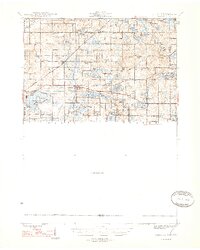
1948 Map of Vandalia
USGS Topo · Published 1948About this map
Vandalia and the surrounding townships of Volinia and Penn are defined by an intricate network of glacial lakes and the agricultural legacy of Youngs Prairie. During the mid-1940s, this region of Cass County remained a rural landscape punctuated by numerous one-room schoolhouses, such as Allegheny Sch and Pleasant Hill Sch, alongside community landmarks like the White Temple and Bethel Ch. The Grand Trunk railroad serves as the primary industrial corridor, connecting settlements like Wakelee and Penn to the wider state.
Find a feature on this map
79 named features on this map. Tap any name to fly to it.
Don’t see what you’re looking for? This feature index may not catch every label — zoom into the map to look around manually.
Map Details
Editions of this 1948 Vandalia Map
5 editions found

Other maps of this area

1914 · Three Rivers
USGS Topo · 1:62,500

1916 · Three Rivers
USGS Topo · 1:62,500

1922 · Schoolcraft
USGS Topo · 1:62,500

1927 · Hartford
USGS Topo · 1:62,500

1931 · Hartford
USGS Topo · 1:62,500

1943 · Three Rivers
USGS Topo · 1:62,500

1943 · Schoolcraft
USGS Topo · 1:62,500

1944 · Marcellus
USGS Topo · 1:62,500

1945 · Cassopolis
USGS Topo · 1:62,500

1946 · Marcellus
USGS Topo · 1:62,500