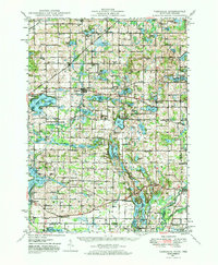
1948 Map of Vandalia
USGS Topo · Published 1973About this map
Glacial lakes and small-scale agriculture define this pocket of Cass and St. Joseph counties shortly after World War II. The landscape is a complex network of water bodies, from the prominent Diamond Lake and Birch Lake to smaller basins like Paradise Lake and Mudd Lake. The village of Vandalia serves as a central hub, connected to the wider region by the Grand Trunk Western RR. The density of community landmarks suggests a settled rural population, with numerous country schools such as Swamp School, Willow Pond Sch, and Hebron Sch scattered alongside local spiritual centers like Chain Lake Ch and White Temple Ch.
Find a feature on this map
109 named features on this map. Tap any name to fly to it.
Don’t see what you’re looking for? This feature index may not catch every label — zoom into the map to look around manually.
Map Details
Editions of this 1948 Vandalia Map
5 editions found

Other maps of this area

1914 · Three Rivers
USGS Topo · 1:62,500

1916 · Three Rivers
USGS Topo · 1:62,500

1922 · Schoolcraft
USGS Topo · 1:62,500

1927 · Hartford
USGS Topo · 1:62,500

1931 · Hartford
USGS Topo · 1:62,500

1943 · Three Rivers
USGS Topo · 1:62,500

1943 · Schoolcraft
USGS Topo · 1:62,500

1944 · Marcellus
USGS Topo · 1:62,500

1945 · Cassopolis
USGS Topo · 1:62,500

1946 · Marcellus
USGS Topo · 1:62,500