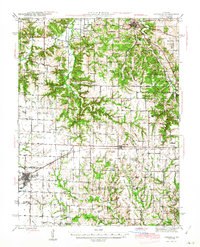
1945 Map of Vandalia
USGS Topo · Published 1945About this map
Vandalia serves as the primary rail hub on this 1945 survey, situated at the junction of the Chicago and Alton RR and several local routes. The landscape transitions from the developed town grid of Vandalia to the dissected hills of northeastern Missouri, where smaller communities like Spencerburg, Curryville, and Madisonville anchor the surrounding rural sections. The importance of the regional rail network is further evidenced by the St Louis and Hannibal RR cutting through the northern reaches near Frankford.
Find a feature on this map
60 named features on this map. Tap any name to fly to it.
Don’t see what you’re looking for? This feature index may not catch every label — zoom into the map to look around manually.
Map Details
Editions of this 1945 Vandalia Map
3 editions found

Other maps of this area

1890 · Louisiana
USGS Topo · 1:125,000

1890 · Mexico
USGS Topo · 1:125,000

1903 · Palmyra
USGS Topo · 1:125,000

1931 · Barry
USGS Topo · 1:62,500

1932 · Hannibal
USGS Topo · 1:62,500

1936 · Hannibal
USGS Topo · 1:48,000

1936 · Barry
USGS Topo · 1:48,000

1937 · Silex
USGS Topo · 1:62,500

1937 · Bowling Green
USGS Topo · 1:62,500

1939 · Silex
USGS Topo · 1:48,000