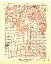
1945 Map of Vandalia
USGS Topo · Published 1945About this map
The Alton railroad corridor defines the development of this Missouri borderland where Ralls, Pike, and Audrain counties meet. In the mid-1940s, Vandalia serves as the primary hub, surrounded by a dense network of rural infrastructure including the Vandalia Cem and numerous family-named schools such as Madisonville Sch and Bridgewater Sch. The landscape is etched by the intricate drainage of the South Fork Spencer Creek and Peno Creek, which dictated the placement of early settlements like Frankford and Spencerburg.
Find a feature on this map
64 named features on this map. Tap any name to fly to it.
Don’t see what you’re looking for? This feature index may not catch every label — zoom into the map to look around manually.
Map Details
Editions of this 1945 Vandalia Map
3 editions found

Other maps of this area

1890 · Louisiana
USGS Topo · 1:125,000

1890 · Mexico
USGS Topo · 1:125,000

1903 · Palmyra
USGS Topo · 1:125,000

1931 · Barry
USGS Topo · 1:62,500

1932 · Hannibal
USGS Topo · 1:62,500

1936 · Hannibal
USGS Topo · 1:48,000

1936 · Barry
USGS Topo · 1:48,000

1937 · Silex
USGS Topo · 1:62,500

1937 · Bowling Green
USGS Topo · 1:62,500

1939 · Silex
USGS Topo · 1:48,000