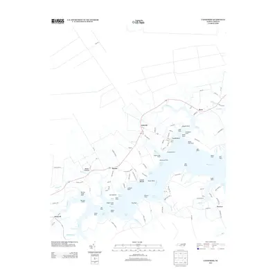
2013 Map of Vandemere
USGS Topo · Published 2013About this map
The waterside community of Vandemere sits at the confluence of Vandemere Cr and the wide Bay River, serving as a central hub for this coastal portion of Pamlico County. The 2013 landscape is defined by its intricate network of peninsulas and points, where land-based features like Poorhouse Point and Graveyard Point reflect a long history of local settlement and community infrastructure along the riverbanks. To the west, small hamlets such as Maribel and Swan Corner are connected by state routes that wind through the low-lying terrain near Parch Corn Bay and Swindell Bay. The map documents a contemporary coastal economy and residence pattern where roads like Lynch Beach Loop Rd provide access to the water's edge at Lynch Beach. From the northern reaches of Mesic to the southern tip near Florence, the geography is a detailed mosaic of tidal creeks and bays, including Mason Bay and Smith Creek, that have dictated the placement of homes and industry for generations.
Find a feature on this map
116 named features on this map. Tap any name to fly to it.
Don’t see what you’re looking for? This feature index may not catch every label — zoom into the map to look around manually.
Map Details
Editions of this 2013 Vandemere Map
This is the sole edition of this map. No revisions or reprints were ever made.
Other maps of this area

1948 · Oriental
USGS Topo · 1:24,000

1950 · Vandemere
USGS Topo · 1:24,000

1950 · Lowland
USGS Topo · 1:24,000

1950 · South Creek
USGS Topo · 1:24,000

1950 · Jones Bay
USGS Topo · 1:24,000

1950 · Aurora
USGS Topo · 1:24,000

1950 · Arapahoe
USGS Topo · 1:24,000

1951 · Arapahoe
USGS Topo · 1:24,000

1951 · Broad Creek
USGS Topo · 1:24,000

1953 · Rocky Mount
USGS Topo · 1:250,000