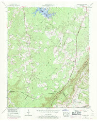
1956 Map of Vandever
USGS Topo · Published 1971About this map
Grassland Farm sits at the northern end of this mid-century survey, representing the agricultural research presence of the University of Tennessee on the Cumberland Plateau. The landscape is defined by the Tennessee Valley Divide, where water begins its journey toward the Sequatchie River or Daddys Creek. A significant development shown is the Tansi Resort, complete with Lake Tansi, a landing strip, and a golf course, marking the era's shift toward recreational land use in the Tennessee highlands.
Find a feature on this map
70 named features on this map. Tap any name to fly to it.
Don’t see what you’re looking for? This feature index may not catch every label — zoom into the map to look around manually.
Map Details
Editions of this 1956 Vandever Map
3 editions found
Other maps of this area

1887 · Kingston
USGS Topo · 1:125,000

1891 · Kingston
USGS Topo · 1:125,000

1892 · Pikeville
USGS Topo · 1:125,000

1893 · Kingston
USGS Topo · 1:125,000

1895 · Pikeville
USGS Topo · 1:125,000

1909 · Sequatchie Valley
USGS Topo · 1:62,500

1910 · Pikeville
USGS Topo · 1:62,500

1912 · Crossville
USGS Topo · 1:62,500

1935 · Melvine
USGS Topo · 1:24,000

1935 · Pennine
USGS Topo · 1:24,000