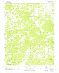
1973 Map of Vanzant
USGS Topo · Published 1975About this map
The Mark Twain National Forest dominates the landscape of eastern Douglas County in this mid-1970s topographic study. Small Ozark communities like Vanzant, Drury, and Buckhart are connected by winding roads through a terrain defined by deep hollows and narrow ridges. The map highlights the rural social fabric of the era, recording numerous religious and memorial sites such as Pleasant Home Ch, Victory Ch, and the Tedrick Cem. Water sources are central to the settlement pattern here, with the West Fork White River and Fox Creek carving through the hills. This document provides a clear view of the area before modern development, detailing family-named landmarks like Nye Ridge and Mushman Hollow alongside early infrastructure like a Jeep Trail and the Davis Roadside Park.
Find a feature on this map
45 named features on this map. Tap any name to fly to it.
Don’t see what you’re looking for? This feature index may not catch every label — zoom into the map to look around manually.
Map Details
Editions of this 1973 Vanzant Map
This is the sole edition of this map. No revisions or reprints were ever made.
Other maps of this area

1937 · Buckhart
USGS Topo · 1:48,000

1939 · Topaz
USGS Topo · 1:62,500

1941 · Topaz
USGS Topo · 1:62,500

1943 · Buckhart
USGS Topo · 1:62,500

1945 · Harrison
USGS Topo · 1:250,000

1945 · Buckhart
USGS Topo · 1:62,500

1949 · Harrison
USGS Topo · 1:250,000

1950 · Cabool SW
USGS Topo · 1:24,000

1951 · Norwood
USGS Topo · 1:24,000

1951 · Mountain Grove South
USGS Topo · 1:24,000