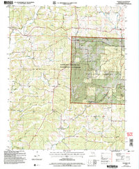
2004 Map of Vanzant
USGS Topo · Published 2006About this map
Vanzant and its surrounding Ozark highlands are captured here at the turn of the 21st century, showing a landscape defined by deep hollows and the headwaters of the West Fork White River. The map reveals a tight-knit network of rural communities, where life centers around local institutions like the Pleasant Home Ch and Victory Ch. This area in Douglas County maintains its traditional settlement patterns, with family legacies preserved in numerous small burial grounds such as Tedrick Cem and Clifty Cem. Conservation efforts are prominent through the Shannon Ranch Conservation Area and the Mark Twain National Forest, which dominate the eastern half of the quadrangle. The terrain is deeply dissected by drainage systems including Fox Creek and Brushy Creek, reflecting the rugged geography of south-central Missouri.
Find a feature on this map
39 named features on this map. Tap any name to fly to it.
Don’t see what you’re looking for? This feature index may not catch every label — zoom into the map to look around manually.
Map Details
Editions of this 2004 Vanzant Map
This is the sole edition of this map. No revisions or reprints were ever made.
Other maps of this area

1937 · Buckhart
USGS Topo · 1:48,000

1939 · Topaz
USGS Topo · 1:62,500

1941 · Topaz
USGS Topo · 1:62,500

1943 · Buckhart
USGS Topo · 1:62,500

1945 · Harrison
USGS Topo · 1:250,000

1945 · Buckhart
USGS Topo · 1:62,500

1949 · Harrison
USGS Topo · 1:250,000

1950 · Cabool SW
USGS Topo · 1:24,000

1951 · Norwood
USGS Topo · 1:24,000

1951 · Mountain Grove South
USGS Topo · 1:24,000