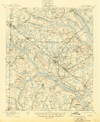
1918 Map of Varnville
USGS Topo · Published 1945About this map
Hampton and Varnville anchor this 1918 survey of the South Carolina Lowcountry, where the Charleston & Western Carolina Railway meets the Hampton & Branchville RR. The landscape is defined by the dense, sprawling wetlands of Caw Caw Swamp and the Whippy Swamp, providing a glimpse into an era when local industry was deeply tied to the timber found along the Lumber River. The map meticulously records the rural social fabric of the early 20th century, noting numerous segregated or small-community landmarks like Jackson Branch School, Enon Church, and McAlhaney School. Strategic river crossings such as Hickory Hill Crossing and Tutens Crossing connect the fragmented high ground between the Salkehatchie River and the Coosawhatchie River. Small-scale operations like Speaks Mill and Jenny and Platts Sawmill are scattered throughout the swamps, illustrating the specialized labor and transportation networks of the day.
Find a feature on this map
81 named features on this map. Tap any name to fly to it.
Don’t see what you’re looking for? This feature index may not catch every label — zoom into the map to look around manually.
Map Details
Editions of this 1918 Varnville Map
4 editions found
Other maps of this area

1918 · Varnville
USGS Topo · 1:62,500

1918 · Yemassee
USGS Topo · 1:62,500

1919 · Pineland
USGS Topo · 1:62,500

1919 · Olar
USGS Topo · 1:62,500

1919 · Shirley
USGS Topo · 1:62,500

1919 · Allendale
USGS Topo · 1:62,500

1919 · Cummings
USGS Topo · 1:62,500

1919 · Lodge
USGS Topo · 1:62,500

1920 · Lodge
USGS Topo · 1:48,000

1920 · Peeples
USGS Topo · 1:62,500