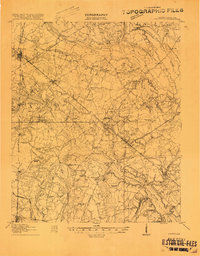
1918 Map of Varnville
USGS Topo · Published 1918About this map
The Coosawhatchie River and Salkehatchie River define the watery landscape of Hampton County in this 1918 survey. The rail-and-river economy of the era is evident in the convergence of the Charleston and Western Carolina RR and the Hampton and Branchville RR at the town of Hampton. While Hampton and Varnville serve as central hubs, the rural interior is dotted with numerous small educational and religious landmarks, including Prince William Church, Macedonia Church, and Millville School.
Find a feature on this map
78 named features on this map. Tap any name to fly to it.
Don’t see what you’re looking for? This feature index may not catch every label — zoom into the map to look around manually.
Map Details
Editions of this 1918 Varnville Map
4 editions found
Other maps of this area

1918 · Varnville
USGS Topo · 1:62,500

1918 · Yemassee
USGS Topo · 1:62,500

1919 · Pineland
USGS Topo · 1:62,500

1919 · Olar
USGS Topo · 1:62,500

1919 · Shirley
USGS Topo · 1:62,500

1919 · Allendale
USGS Topo · 1:62,500

1919 · Cummings
USGS Topo · 1:62,500

1919 · Lodge
USGS Topo · 1:62,500

1920 · Lodge
USGS Topo · 1:48,000

1920 · Peeples
USGS Topo · 1:62,500