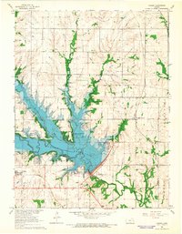
1965 Map of Vassar
USGS Topo · Published 1966About this map
The newly established Pomona Reservoir dominates this mid-1960s landscape, illustrating the massive flood control transformations of the Missouri River Basin project. The reservoir’s irregular shoreline, marked at Normal Pool Elevation 974, inundated the valleys of Hundred and Ten Mile Creek and Dragoon Creek, creating a series of recreation zones including Vassar State Park and the Management Recreation Area. South of the water, the settlement of Vassar sits along the Missouri Pacific railroad line, while Michigan Valley remains to the northeast.
Find a feature on this map
32 named features on this map. Tap any name to fly to it.
Don’t see what you’re looking for? This feature index may not catch every label — zoom into the map to look around manually.
Map Details
Editions of this 1965 Vassar Map
2 editions found
Other maps of this area

1885 · Lawrence
USGS Topo · 1:125,000

1889 · Burlingame
USGS Topo · 1:125,000

1889 · Lawrence
USGS Topo · 1:125,000

1894 · Burlingame
USGS Topo · 1:125,000

1947 · Lawrence
USGS Topo · 1:250,000

1950 · Lawrence
USGS Topo · 1:250,000

1955 · Overbrook
USGS Topo · 1:24,000

1955 · Carbondale
USGS Topo · 1:24,000

1955 · Globe
USGS Topo · 1:24,000

1956 · Pomona
USGS Topo · 1:24,000