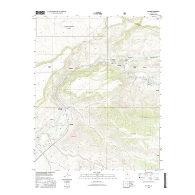
2017 Map of Velarde
USGS Topo · Published 2017About this map
The Rio Grande carves a deep path through northern New Mexico in this 2017 survey, defining the life and agricultural layout of settlements like Velarde and Dixon. Irrigation is central to the landscape, with historic acequias such as Chicos Ditch, El Llano Ditch, and La Plaza Ditch feeding small plots of land along the river's edge. The terrain rises sharply away from the water, moving from the lush valley floor toward landmarks like Black Mesa and into the rugged southern edges of the Carson National Forest. For genealogists and local historians, the map identifies key community centers and burial sites, including the Velarde Cemetery and El Santuario Cemetery. Small hamlets such as La Cienaga, La Bolsa, and Rinconada are tucked into the bends of the river and Embudo Creek, illustrating the long-standing settlement patterns that have existed in this high-desert environment for generations.
Find a feature on this map
51 named features on this map. Tap any name to fly to it.
Don’t see what you’re looking for? This feature index may not catch every label — zoom into the map to look around manually.
Map Details
Editions of this 2017 Velarde Map
This is the sole edition of this map. No revisions or reprints were ever made.
Other maps of this area

1918 · Abiquiu
USGS Topo · 1:125,000

1953 · San Juan Pueblo
USGS Topo · 1:24,000

1953 · Lyden
USGS Topo · 1:24,000

1953 · Truchas
USGS Topo · 1:24,000

1953 · Velarde
USGS Topo · 1:24,000

1953 · Trampas
USGS Topo · 1:24,000

1953 · Chimayo
USGS Topo · 1:24,000

1953 · Ojo Caliente
USGS Topo · 1:24,000

1953 · San Juan Pueblo
USGS Topo · 1:62,500

1954 · Raton
USGS Topo · 1:250,000