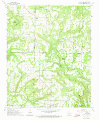
1965 Map of Velvet Ridge
USGS Topo · Published 1973About this map
The community of Denmark serves as a northern focal point for this rural landscape in White and Jackson Counties during the mid-1960s. Surveyed by the U.S. Geological Survey and the Arkansas Geological Commission, the terrain is defined by the winding paths of Glaise Creek and Sugar Creek, which carve through the prominent uplands of Throckmorton Hill and Round Mountain. The map reveals a deeply established rural social fabric, marked by small family and community burial grounds such as Morris Cem, Bethlehem Cem, and Smith Cem. Local life centers around the Church of Christ near the Velvet Ridge Cem, and the cluster of dwellings at Caplener and Heffington. Small-scale land use is evident through numerous labeled quarries and gravel pits, while an extensive network of field and fence lines, often visible only from aerial photographs, illustrates the area's agricultural divisions before significant modern consolidation.
Find a feature on this map
3 named features on this map. Tap any name to fly to it.
Don’t see what you’re looking for? This feature index may not catch every label — zoom into the map to look around manually.
Map Details
Editions of this 1965 Velvet Ridge Map
2 editions found
Other maps of this area

1890 · Batesville
USGS Topo · 1:125,000

1891 · Batesville
USGS Topo · 1:125,000

1935 · Newport
USGS Topo · 1:62,500

1935 · Augusta
USGS Topo · 1:62,500

1935 · Bald Knob
USGS Topo · 1:62,500

1953 · Memphis
USGS Topo · 1:250,000

1956 · Memphis
USGS Topo · 1:250,000

1957 · Augusta
USGS Topo · 1:62,500
1962 · Olyphant
USGS Topo · 1:24,000
1962 · Newport
USGS Topo · 1:62,500