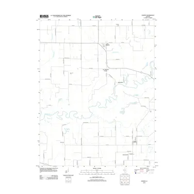
2012 Map of Venedy
USGS Topo · Published 2012About this map
The Kaskaskia River snakes across this Southern Illinois landscape, creating a complex network of oxbows and backwaters south of New Memphis. This 2012 survey illustrates the distinct agricultural and settlement patterns of Washington and Clinton counties, where straight section-line roads like Zimmermann Rd and Zinck Rd contrast with the wandering riverbank topography. Local heritage is rooted in small communities such as Venedy, Johannisburg, and the riverfront area of Wertenberg. The map provides specific locations for genealogical research, including Saint Johns Evangelical Cem and Miller Cem, while also documenting legacy locations like New Memphis Station. Former educational landmarks are preserved in the names of thoroughfares like Woodland School Rd and Liebig School Rd, which hint at the historical placement of rural schoolhouses in this farming region. Significant water features such as Queens Lake, Calamus Lake, and the Rayhill Slough define the bottomlands, reflecting the enduring influence of the river on local land use.
Find a feature on this map
81 named features on this map. Tap any name to fly to it.
Don’t see what you’re looking for? This feature index may not catch every label — zoom into the map to look around manually.
Map Details
Editions of this 2012 Venedy Map
This is the sole edition of this map. No revisions or reprints were ever made.
Other maps of this area

1906 · Breese
USGS Topo · 1:62,500

1907 · Breese
USGS Topo · 1:62,500

1907 · Belleville
USGS Topo · 1:62,500

1910 · Okawville
USGS Topo · 1:62,500

1912 · New Athens
USGS Topo · 1:62,500

1935 · Lebanon
USGS Topo · 1:24,000

1940 · Okawville
USGS Topo · 1:62,500

1949 · Lebanon
USGS Topo · 1:24,000
1954 · Lebanon
USGS Topo · 1:24,000
1954 · Mascoutah
USGS Topo · 1:24,000