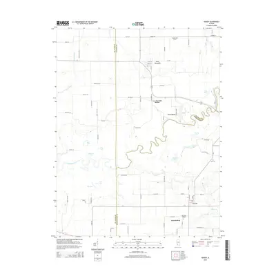
2015 Map of Venedy
USGS Topo · Published 2015About this map
The Kaskaskia River meanders through a landscape defined by oxbow lakes and wetlands, marking the border between St. Clair, Clinton, and Washington counties. This river corridor features a dense network of named water bodies, including Queens Lake, Swan Lake, and Muddy Lake, which reflect the dynamic hydrology of the floodplain. The small settlements of New Memphis, Wertenberg, and Venedy are connected by a grid of rural roads, many of which bear local family or school names like Woodland School Rd and Liebig School Rd.
Find a feature on this map
78 named features on this map. Tap any name to fly to it.
Don’t see what you’re looking for? This feature index may not catch every label — zoom into the map to look around manually.
Map Details
Editions of this 2015 Venedy Map
This is the sole edition of this map. No revisions or reprints were ever made.
Other maps of this area

1906 · Breese
USGS Topo · 1:62,500

1907 · Breese
USGS Topo · 1:62,500

1907 · Belleville
USGS Topo · 1:62,500

1910 · Okawville
USGS Topo · 1:62,500

1912 · New Athens
USGS Topo · 1:62,500

1935 · Lebanon
USGS Topo · 1:24,000

1940 · Okawville
USGS Topo · 1:62,500

1949 · Lebanon
USGS Topo · 1:24,000
1954 · Lebanon
USGS Topo · 1:24,000
1954 · Mascoutah
USGS Topo · 1:24,000