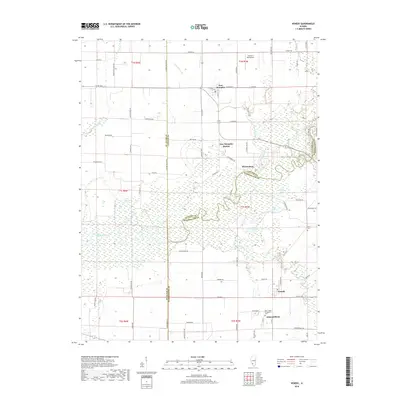
2018 Map of Venedy
USGS Topo · Published 2018About this map
The Kaskaskia River snakes through the center of this southern Illinois landscape, defining the boundaries between St. Clair, Clinton, and Washington counties. This riverine environment is characterized by a complex network of wetlands and oxbow formations, including Calamus Lake, Muddy Lake, and Swan Lake. The small settlements of Johannisburg and Venedy anchor the southern portion of the map, connected by rural routes such as Co Hwy 6 and Spook Rd.
Find a feature on this map
85 named features on this map. Tap any name to fly to it.
Don’t see what you’re looking for? This feature index may not catch every label — zoom into the map to look around manually.
Map Details
Editions of this 2018 Venedy Map
This is the sole edition of this map. No revisions or reprints were ever made.
Other maps of this area

1906 · Breese
USGS Topo · 1:62,500

1907 · Breese
USGS Topo · 1:62,500

1907 · Belleville
USGS Topo · 1:62,500

1910 · Okawville
USGS Topo · 1:62,500

1912 · New Athens
USGS Topo · 1:62,500

1935 · Lebanon
USGS Topo · 1:24,000

1940 · Okawville
USGS Topo · 1:62,500

1949 · Lebanon
USGS Topo · 1:24,000
1954 · Lebanon
USGS Topo · 1:24,000
1954 · Mascoutah
USGS Topo · 1:24,000