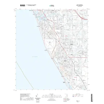
2021 Map of Venice
USGS Topo · Published 2021About this map
The Intracoastal Waterway carves through the heart of this coastal landscape, separating the mainland from the barrier islands of Casey Key and Manasota Key. This 2021 survey reveals a dense suburban network of residential developments including Venice Gardens, South Venice, and Venice Groves, alongside the established municipal centers of Venice and Nokomis. The interplay of natural and engineered waterways is evident in the alignment of the Blackburn Canal and the complex tidal basins of Roberts Bay and Dona Bay. Coastal features like Venice Inlet and Caspersen Beach anchor the shoreline, while the Venice Municipal Airport occupies a significant tract of the southern waterfront. The map also traces modern recreational corridors like the Legacy Trail and the Florida Circumnavigational Saltwater Paddling Trail, highlighting the region's focus on both land and water-based transit.
Find a feature on this map
49 named features on this map. Tap any name to fly to it.
Don’t see what you’re looking for? This feature index may not catch every label — zoom into the map to look around manually.
Map Details
Editions of this 2021 Venice Map
This is the sole edition of this map. No revisions or reprints were ever made.
Other maps of this area

1943 · Laurel
USGS Topo · 1:24,000

1944 · Bird Keys
USGS Topo · 1:31,680

1944 · Lower Myakka Lake
USGS Topo · 1:31,680

1944 · Myakka River
USGS Topo · 1:31,680

1944 · Laurel
USGS Topo · 1:31,680

1944 · Venice
USGS Topo · 1:31,680

1956 · Englewood
USGS Topo · 1:24,000

1956 · Tampa
USGS Topo · 1:250,000

1956 · Charlotte Harbor
USGS Topo · 1:250,000

1957 · Englewood NW
USGS Topo · 1:24,000