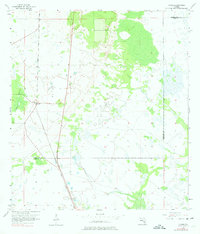
1957 Map of Venus
USGS Topo · Published 1975About this map
Venus occupies a central position within this South Florida landscape, situated along the north-south corridor of the Atlantic Coast Line railroad. Based on surveys from 1957, the map reveals a terrain defined by subtle elevation changes and an intricate network of wetlands and seasonal ponds. The northern portion of the quadrangle shows significant agricultural or clearing patterns, while the south remains dominated by natural drainage features like Platt Branch. The border between Highlands Co and Glades Co cuts across the southern portion of the sheet, marking a transition into the more sparsely settled ranch and marshlands typical of the Lake Okeechobee interior during the mid-twentieth century.
Find a feature on this map
4 named features on this map. Tap any name to fly to it.
Don’t see what you’re looking for? This feature index may not catch every label — zoom into the map to look around manually.
Map Details
Editions of this 1957 Venus Map
3 editions found
Other maps of this area

1953 · Brighton NW
USGS Topo · 1:24,000

1953 · Brighton SW
USGS Topo · 1:24,000

1953 · Venus NW
USGS Topo · 1:24,000

1953 · Childs
USGS Topo · 1:24,000

1956 · West Palm Beach
USGS Topo · 1:250,000

1956 · Fort Pierce
USGS Topo · 1:250,000

1957 · West Palm Beach
USGS Topo · 1:250,000

1957 · Venus
USGS Topo · 1:24,000

1957 · Venus SW
USGS Topo · 1:24,000

1958 · Fort Pierce
USGS Topo · 1:250,000