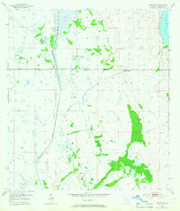
1953 Map of Venus NW
USGS Topo · Published 1966About this map
Fisheating Creek meanders through this portion of the Florida highlands, defining a landscape of wetlands and scattered high ground as it appeared in the early 1950s. The map reveals a sparsely settled interior where the Carlton Ranch stands as a primary landmark of the cattle and ranching industry common to this region. The presence of the Footman Trail suggests established overland routes through the marshes and hammocks, connecting the ranch lands to the surrounding territory. In the northeast corner, a portion of Lake Placid is visible, contrasting the open creek basins. Numerous Windmill labels are scattered across the sheet, marking essential water points for livestock in the prairie-like terrain. The drainage patterns of Bootheel Creek further illustrate the complex hydrology of this part of Highlands County before modern development altered many of the natural watercourses.
Find a feature on this map
8 named features on this map. Tap any name to fly to it.
Don’t see what you’re looking for? This feature index may not catch every label — zoom into the map to look around manually.
Map Details
Editions of this 1953 Venus NW Map
3 editions found
Other maps of this area

1952 · Lake Placid
USGS Topo · 1:24,000

1953 · Lake June In Winter
USGS Topo · 1:24,000

1953 · Venus NW
USGS Topo · 1:24,000

1953 · Crewsville SE
USGS Topo · 1:24,000

1953 · Childs
USGS Topo · 1:24,000

1956 · Fort Pierce
USGS Topo · 1:250,000

1957 · Long Island Marsh SE
USGS Topo · 1:24,000

1957 · Venus
USGS Topo · 1:24,000

1957 · Venus SW
USGS Topo · 1:24,000

1957 · Long Island Marsh NE
USGS Topo · 1:24,000