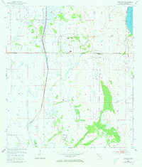
1953 Map of Venus NW
USGS Topo · Published 1973About this map
Fisheating Creek meanders through the marshy lowlands of Highlands County in this mid-century survey, which combines plane-table work from 1953 with 1972 aerial photo revisions. The landscape is defined by its seasonal wetlands and cattle ranching economy, centered on the Carlton Ranch in the northeastern section of the quadrangle. A network of windmills scattered across the terrain suggests the vital importance of groundwater management for the area's agricultural operations. To the southeast, the Footman Trail cuts through the vegetation near Bootheel Creek, while the shoreline of Lake Placid frames the far northeastern corner. This map documents a period before significant modern development, showing a land where travel and industry were still dictated by the natural drainage patterns of the Florida interior.
Find a feature on this map
7 named features on this map. Tap any name to fly to it.
Don’t see what you’re looking for? This feature index may not catch every label — zoom into the map to look around manually.
Map Details
Editions of this 1953 Venus NW Map
3 editions found
Other maps of this area

1952 · Lake Placid
USGS Topo · 1:24,000

1953 · Lake June In Winter
USGS Topo · 1:24,000

1953 · Venus NW
USGS Topo · 1:24,000

1953 · Crewsville SE
USGS Topo · 1:24,000

1953 · Childs
USGS Topo · 1:24,000

1956 · Fort Pierce
USGS Topo · 1:250,000

1957 · Long Island Marsh SE
USGS Topo · 1:24,000

1957 · Venus
USGS Topo · 1:24,000

1957 · Venus SW
USGS Topo · 1:24,000

1957 · Long Island Marsh NE
USGS Topo · 1:24,000