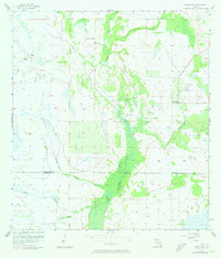
1957 Map of Venus SW
USGS Topo · Published 1973About this map
The swampy lowlands along the boundary of Highlands Co and Glades Co define this mid-century survey of the Florida interior. The landscape is dominated by a complex network of wetlands and sluggish watercourses, including the prominent Fisheating Creek and a series of named drainages like Joe Slough, John Henry Slough, and Gannet Slough. These features reveal a territory where water management and natural drainage dictated the patterns of human activity. Settled life is sparse, centered near Old Venus on the eastern edge of the quadrangle. Small-scale aviation and land access are indicated by a solitary Landing Strip, highlighting the necessity of air travel in navigating the more isolated reaches of the South Florida wetlands. The map provides a look at the region before significant modern development, showing the transition between natural marshlands and early agricultural clearings near Clay Slough.
Find a feature on this map
9 named features on this map. Tap any name to fly to it.
Don’t see what you’re looking for? This feature index may not catch every label — zoom into the map to look around manually.
Map Details
Editions of this 1957 Venus SW Map
3 editions found
Other maps of this area

1953 · Venus NW
USGS Topo · 1:24,000

1953 · Childs
USGS Topo · 1:24,000

1956 · Telegraph Swamp NE
USGS Topo · 1:24,000

1956 · West Palm Beach
USGS Topo · 1:250,000

1956 · Fort Pierce
USGS Topo · 1:250,000

1957 · West Palm Beach
USGS Topo · 1:250,000

1957 · Long Island Marsh SE
USGS Topo · 1:24,000

1957 · Venus
USGS Topo · 1:24,000

1957 · Venus SW
USGS Topo · 1:24,000

1957 · Long Island Marsh NE
USGS Topo · 1:24,000