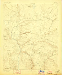
1892 Map of Verde
USGS Topo · Published 1897About this map
Fort Verde serves as a central hub on this late 19th-century landscape, positioned along the Verde River as a point of contact between military presence and early settlements like Cornville and Payson. The geography is defined by the sharp descent from the Mogollon Mesa into the rugged canyon systems of the Diablo Canyon and Deadmans Canyon. The survey captures the region’s early infrastructure, including The Tunnel on the mesa and the notable Natural Bridge near the settlement of Pine. Water sources were clearly critical for these frontier outposts, as evidenced by the mapping of numerous tanks and springs such as Rattlesnake Tank and Wildcat Spring. This survey, conducted by A.P. Davis under the direction of J.W. Powell, illustrates the complex relationship between the high plateau and the deep basins of Yavapai and Maricopa counties.
Find a feature on this map
56 named features on this map. Tap any name to fly to it.
Don’t see what you’re looking for? This feature index may not catch every label — zoom into the map to look around manually.
Map Details
Editions of this 1892 Verde Map
5 editions found
Other maps of this area

1883 · Tusayan
USGS Topo · 1:250,000

1886 · Tusayan
USGS Topo · 1:250,000

1886 · San Francisco Mtns
USGS Topo · 1:250,000

1886 · Chino
USGS Topo · 1:250,000

1886 · Holbrook
USGS Topo · 1:250,000

1887 · Verde
USGS Topo · 1:250,000

1887 · Prescott
USGS Topo · 1:250,000

1891 · San Francisco Mtns
USGS Topo · 1:250,000

1891 · Chino
USGS Topo · 1:250,000

1892 · Verde
USGS Topo · 1:250,000