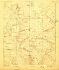
1892 Map of Verde
USGS Topo · Published 1910About this map
Fort Verde stands at the heart of this central Arizona landscape, anchoring a network of early settlements and rugged terrain as documented during an 1885 survey. The map reveals a land defined by dramatic transitions, where the Verde River cuts through the territory between the Yavapai and Maricopa borders. To the north and east, the massive Mogollon Mesa and the Mazatzal Mountains dictate the flow of water and human movement, with landmarks like Natural Bridge and The Tunnel providing points of reference for travelers. Early homesteads and ranching outposts such as Potato Ranch, Cornville, and Payson are already established. The survey also captures prominent natural features including Mormon Lake and the deep incision of Canyon Diablo, illustrating the territorial geography before the era of intensive modern development.
Find a feature on this map
59 named features on this map. Tap any name to fly to it.
Don’t see what you’re looking for? This feature index may not catch every label — zoom into the map to look around manually.
Map Details
Editions of this 1892 Verde Map
5 editions found
Other maps of this area

1883 · Tusayan
USGS Topo · 1:250,000

1886 · Tusayan
USGS Topo · 1:250,000

1886 · San Francisco Mtns
USGS Topo · 1:250,000

1886 · Chino
USGS Topo · 1:250,000

1886 · Holbrook
USGS Topo · 1:250,000

1887 · Verde
USGS Topo · 1:250,000

1887 · Prescott
USGS Topo · 1:250,000

1891 · San Francisco Mtns
USGS Topo · 1:250,000

1891 · Chino
USGS Topo · 1:250,000

1892 · Verde
USGS Topo · 1:250,000