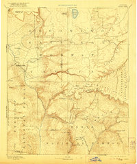
1892 Map of Verde
USGS Topo · Published 1922About this map
The Verde River serves as the primary drainage for this transition zone between the high plateau and the desert floor, as recorded during the late nineteenth-century reconnaissance surveys. Settled pockets like Fort Verde, Cornville, and Aultman appear along the river valleys, while higher elevations are dominated by early designations of the Coconino National Forest and Tonto National Forest. Notable landmarks such as Montezuma Castle National Monument and the Natural Bridge emphasize the unique geological and archaeological character of the Mogollon Rim country. The map captures the infrastructure of early Arizona ranching and travel, marking seasonal resources like Battlesnake Tank and Pine Spring. Remote outposts including Strawberry, Pine, and Payson are already established along the winding trails that navigate the complex canyons of the Mazatzal Mountains and the steep descent of the Deadmans Canyon.
Find a feature on this map
64 named features on this map. Tap any name to fly to it.
Don’t see what you’re looking for? This feature index may not catch every label — zoom into the map to look around manually.
Map Details
Editions of this 1892 Verde Map
5 editions found
Other maps of this area

1883 · Tusayan
USGS Topo · 1:250,000

1886 · Tusayan
USGS Topo · 1:250,000

1886 · San Francisco Mtns
USGS Topo · 1:250,000

1886 · Chino
USGS Topo · 1:250,000

1886 · Holbrook
USGS Topo · 1:250,000

1887 · Verde
USGS Topo · 1:250,000

1887 · Prescott
USGS Topo · 1:250,000

1891 · San Francisco Mtns
USGS Topo · 1:250,000

1891 · Chino
USGS Topo · 1:250,000

1892 · Verde
USGS Topo · 1:250,000