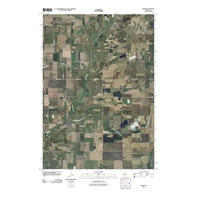
2010 Map of Verdi
USGS Topo · Published 2010About this map
The settlement of Verdi anchors this agricultural landscape in Lincoln County, defined by a grid of rural roads and the meandering drainage of Flandreau Creek. At the village center, the Verdi Post Office stands near the intersection of Center St and Front St, serving as a focal point for the surrounding farming community. The terrain is characterized by a series of waterways, including Spring Creek, Willow Creek, and the East Branch Flandreau Creek, which cut across the structured township-and-range road system.
Find a feature on this map
28 named features on this map. Tap any name to fly to it.
Don’t see what you’re looking for? This feature index may not catch every label — zoom into the map to look around manually.
Map Details
Editions of this 2010 Verdi Map
This is the sole edition of this map. No revisions or reprints were ever made.
Other maps of this area

1953 · Watertown
USGS Topo · 1:250,000

1958 · Watertown
USGS Topo · 1:250,000

1963 · Tyler
USGS Topo · 1:24,000

1967 · Pipestone North
USGS Topo · 1:24,000

1967 · Ruthton NW
USGS Topo · 1:24,000

1967 · Elkton SW
USGS Topo · 1:24,000

1967 · Verdi
USGS Topo · 1:24,000

1967 · Lake Benton
USGS Topo · 1:24,000

1967 · Lake Benton SW
USGS Topo · 1:24,000
1967 · Holland
USGS Topo · 1:24,000