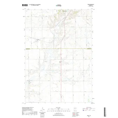
2019 Map of Verdi
USGS Topo · Published 2019About this map
The town of Verdi sits in the southwestern portion of Lincoln County, just north of the Lincoln and Pipestone county line. This landscape is defined by the Coteau des Prairies, a high plateau that rises prominently above the surrounding plains. The topography here influences the drainage of several local waterways, including the winding paths of Willow Cr and the larger Flandreau Cr system. In the northern reaches, the southern edges of Lake Benton introduce significant wetland and basin features. The map illustrates a strict section-line road grid typical of the late 20th and early 21st century, with major routes like Co Hwy 2 and Co Rd 9 connecting the rural farmsteads that occupy the township divisions of t109n r46w and t109n r45w.
Find a feature on this map
42 named features on this map. Tap any name to fly to it.
Don’t see what you’re looking for? This feature index may not catch every label — zoom into the map to look around manually.
Map Details
Editions of this 2019 Verdi Map
This is the sole edition of this map. No revisions or reprints were ever made.
Other maps of this area

1953 · Watertown
USGS Topo · 1:250,000

1958 · Watertown
USGS Topo · 1:250,000

1963 · Tyler
USGS Topo · 1:24,000

1967 · Pipestone North
USGS Topo · 1:24,000

1967 · Ruthton NW
USGS Topo · 1:24,000

1967 · Elkton SW
USGS Topo · 1:24,000

1967 · Verdi
USGS Topo · 1:24,000

1967 · Lake Benton
USGS Topo · 1:24,000

1967 · Lake Benton SW
USGS Topo · 1:24,000
1967 · Holland
USGS Topo · 1:24,000