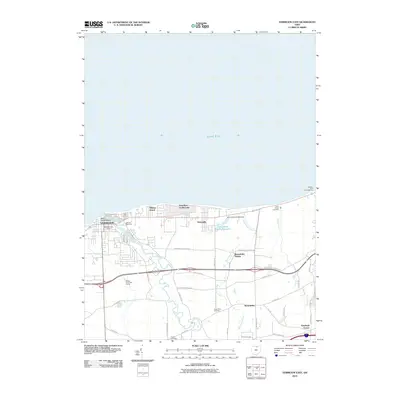
2010 Map of Vermilion East
USGS Topo · Published 2010About this map
The southern shore of Lake Erie defines this 2010 survey, where the Vermilion River meets the lake at the established settlement of Vermilion. The landscape transitions from the developed waterfront at Main Street Beach and Elberta Beach to the rural interior. Genealogical interest is centered on family landmarks like the Claus Family Cemetery and the Brownhelm Cemetery, along with smaller crossroads such as Kendeigh Corner and Sunnyside. Inland, the terrain is shaped by several waterways, including Brownhelm Creek and Quarry Creek, while the Lake Haven Estates Reservoir and its accompanying Lake Haven Estates Dam highlight local water management. The transportation network is a mix of historic routes like N Ridge Rd and modern corridors, supporting a nautical and residential economy evidenced by the Jeavons BoatYard and Beaver Park North Marina.
Find a feature on this map
41 named features on this map. Tap any name to fly to it.
Don’t see what you’re looking for? This feature index may not catch every label — zoom into the map to look around manually.
Map Details
Editions of this 2010 Vermilion East Map
This is the sole edition of this map. No revisions or reprints were ever made.
Other maps of this area

1901 · Oberlin
USGS Topo · 1:62,500

1903 · Vermilion
USGS Topo · 1:62,500

1903 · Oberlin
USGS Topo · 1:62,500

1956 · Toledo
USGS Topo · 1:250,000

1959 · Berlin Heights
USGS Topo · 1:24,000

1959 · Vermilion East
USGS Topo · 1:24,000

1959 · Vermilion West
USGS Topo · 1:24,000

1959 · Kipton
USGS Topo · 1:24,000

1960 · Oberlin
USGS Topo · 1:24,000
1960 · Lorain
USGS Topo · 1:24,000