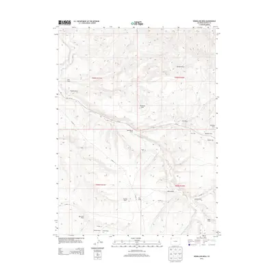
2013 Map of Vermillion Mesa
USGS Topo · Published 2013About this map
Vermillion Mesa dominates this corner of Moffat County, characterized by a complex network of dry draws and scattered natural springs. The presence of the Hughes Cem and Hefley Cabin suggest a legacy of early ranching and homesteading in this arid Colorado landscape. While Vermillion Creek cuts through the western terrain, much of the area's water sources are concentrated at sites like Hughes Spring, Willow Spring, and Loomis Spring. The map documents the vital rural road system, including Co-318 and various county routes such as CO Road 10, which provide access through the significant elevation changes between Hughes Flat and the surrounding draws. This survey provides a clear look at how topography dictated the placement of early settlements and travel corridors in the high desert.
Find a feature on this map
30 named features on this map. Tap any name to fly to it.
Don’t see what you’re looking for? This feature index may not catch every label — zoom into the map to look around manually.
Map Details
Editions of this 2013 Vermillion Mesa Map
This is the sole edition of this map. No revisions or reprints were ever made.
Other maps of this area

1954 · Vernal
USGS Topo · 1:250,000

1958 · Vernal
USGS Topo · 1:250,000

1960 · Vernal
USGS Topo · 1:250,000

1966 · G Spring
USGS Topo · 1:24,000
1966 · Limestone Hill
USGS Topo · 1:24,000

1966 · Big Joe Basin
USGS Topo · 1:24,000

1966 · Irish Canyon
USGS Topo · 1:24,000

1966 · Sheephead Basin
USGS Topo · 1:24,000
1966 · Greystone
USGS Topo · 1:24,000
1966 · Zenobia Peak
USGS Topo · 1:24,000