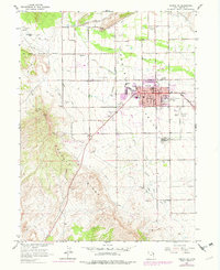
1964 Map of Vernal NE
USGS Topo · Published 1979About this map
Asphalt Ridge dominates the western landscape of this mid-century survey, a geological feature that supported local industry at the Asphalt Mine. The settlement of Maeser sits to the northwest of the expanding city of Vernal, where the street grid is anchored by essential community landmarks including the Vernal Sch, Uintah HS, and the National Guard Armory. The infrastructure of the Uinta Basin is clearly visible through a complex network of irrigation works, such as the Feeder Canal and Steinaker Service Canal, which divert water from Ashley Creek and the Steinaker Res to the surrounding valley. Local history is preserved in several burial grounds, including Vernal Memorial Park and Fairview Cem, while evidence of the region’s military past remains in the Old Military Reservation Boundary cutting across the northern foothills.
Find a feature on this map
40 named features on this map. Tap any name to fly to it.
Don’t see what you’re looking for? This feature index may not catch every label — zoom into the map to look around manually.
Map Details
Editions of this 1964 Vernal NE Map
2 editions found
Other maps of this area

1885 · Ashley
USGS Topo · 1:250,000

1906 · Marsh Peak
USGS Topo · 1:125,000

1907 · Jensen
USGS Topo · 1:125,000

1908 · Marsh Peak
USGS Topo · 1:125,000

1910 · Jensen
USGS Topo · 1:125,000

1917 · Vernal
USGS Topo · 1:125,000

1954 · Vernal
USGS Topo · 1:250,000

1958 · Vernal
USGS Topo · 1:250,000

1960 · Vernal
USGS Topo · 1:250,000

1964 · Vernal NE
USGS Topo · 1:24,000