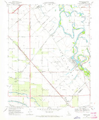
1969 Map of Vernalis
USGS Topo · Published 1972About this map
San Joaquin River meanders through this landscape, marking the transition from the rich agricultural floor of the Central Valley to the engineered water systems essential to California's growth. The map captures a moment in the late 1960s when traditional ranching and farming infrastructure coexisted with massive public works like the Hetch Hetchy Aqueduct, Delta-Mendota Canal, and California Aqueduct. Along the river’s edge, the San Joaquin City (Site) and its corresponding San Joaquin City Historical Monument serve as silent markers of an earlier era of river-based commerce.
Find a feature on this map
50 named features on this map. Tap any name to fly to it.
Don’t see what you’re looking for? This feature index may not catch every label — zoom into the map to look around manually.
Map Details
Editions of this 1969 Vernalis Map
2 editions found
Other maps of this area

1913 · Romain
USGS Topo · 1:31,680

1914 · Manteca
USGS Topo · 1:31,680

1914 · Union Island
USGS Topo · 1:31,680

1915 · Vernalis
USGS Topo · 1:31,680

1915 · Lathrop
USGS Topo · 1:31,680

1915 · Ripon
USGS Topo · 1:31,680

1915 · Westley
USGS Topo · 1:31,680

1916 · Tracy
USGS Topo · 1:31,680

1916 · Romain
USGS Topo · 1:31,680

1922 · Carbona
USGS Topo · 1:62,500