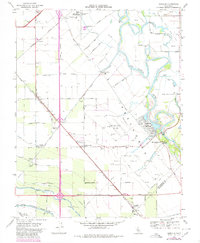
1969 Map of Vernalis
USGS Topo · Published 1980About this map
The San Joaquin River defines the agricultural and industrial landscape of this region at the intersection of San Joaquin and Stanislaus counties. This photorevised survey documents a complex water management infrastructure, where the California Aqueduct, Mendota Canal, and the Hetch Hetchy Aqueduct converge south of Vernalis. The map captures the footprint of the San Joaquin City (Site), marked with a Historical Monument, alongside the active local aviation at New Jerusalem Airport and the nearby New Jerusalem Sch. To the north, the Deuel Vocational Institution sits near the Western Pacific line, while the Vernalis Gas Field and Pacific Gas and Electric Field indicate the importance of energy extraction. This era shows a transition from traditional rail-dependent settlements like Cochrane and Ohm toward the large-scale irrigation projects that transformed the Central Valley.
Find a feature on this map
44 named features on this map. Tap any name to fly to it.
Don’t see what you’re looking for? This feature index may not catch every label — zoom into the map to look around manually.
Map Details
Editions of this 1969 Vernalis Map
2 editions found
Other maps of this area

1913 · Romain
USGS Topo · 1:31,680

1914 · Manteca
USGS Topo · 1:31,680

1914 · Union Island
USGS Topo · 1:31,680

1915 · Vernalis
USGS Topo · 1:31,680

1915 · Lathrop
USGS Topo · 1:31,680

1915 · Ripon
USGS Topo · 1:31,680

1915 · Westley
USGS Topo · 1:31,680

1916 · Tracy
USGS Topo · 1:31,680

1916 · Romain
USGS Topo · 1:31,680

1922 · Carbona
USGS Topo · 1:62,500