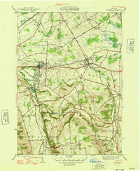
1948 Map of Vernon
USGS Topo · Published 1948About this map
Sherrill and Kenwood anchor the western edge of this 1948 survey, where the border of Oneida and Madison Counties follows the winding path of Oneida Creek. The landscape transition from the industrial developments near the New York Central railroad to the agricultural uplands of Eaton Hill is well-defined. Local landmarks such as the Fairgrounds in Vernon and the Airway Beacon to the north highlight the community infrastructure of the mid-century era.
Find a feature on this map
69 named features on this map. Tap any name to fly to it.
Don’t see what you’re looking for? This feature index may not catch every label — zoom into the map to look around manually.
Map Details
Editions of this 1948 Vernon Map
2 editions found
Other maps of this area

1895 · Oriskany
USGS Topo · 1:62,500

1895 · Oneida
USGS Topo · 1:62,500

1898 · Oneida
USGS Topo · 1:62,500

1898 · Oriskany
USGS Topo · 1:62,500

1902 · Morrisville
USGS Topo · 1:62,500

1902 · Oneida
USGS Topo · 1:62,500

1907 · Sangerfield
USGS Topo · 1:62,500

1939 · Oneida
USGS Topo · 1:62,500

1943 · Morrisville
USGS Topo · 1:24,000

1943 · Sangerfield
USGS Topo · 1:62,500