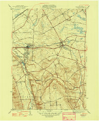
1948 Map of Vernon
USGS Topo · Published 1948About this map
Sherrill and Kenwood anchor the western edge of this 1948 survey, where the New York Central railroad and the Seneca Turnpike define the region's transport corridor. The landscape is marked by small agricultural hamlets like Vernon Center and Five Chimneys Cor, linked by a dense network of country roads such as Knoxboro Road and Peterboro Road. This topography reveals the intricate water network feeding the area, including Sconondoa Creek and the southern rise of Eaton Hill. Local history and genealogy are well-represented by several family-named landmarks and rural burial grounds, including the Valley View Cem and the Swinner Cem. The presence of an Airway Beacon and numerous district schools like the Indian Sch and Bennetts Corners Sch highlights the community infrastructure in place just after the post-war period.
Find a feature on this map
75 named features on this map. Tap any name to fly to it.
Don’t see what you’re looking for? This feature index may not catch every label — zoom into the map to look around manually.
Map Details
Editions of this 1948 Vernon Map
2 editions found
Other maps of this area

1895 · Oriskany
USGS Topo · 1:62,500

1895 · Oneida
USGS Topo · 1:62,500

1898 · Oneida
USGS Topo · 1:62,500

1898 · Oriskany
USGS Topo · 1:62,500

1902 · Morrisville
USGS Topo · 1:62,500

1902 · Oneida
USGS Topo · 1:62,500

1907 · Sangerfield
USGS Topo · 1:62,500

1939 · Oneida
USGS Topo · 1:62,500

1943 · Morrisville
USGS Topo · 1:24,000

1943 · Sangerfield
USGS Topo · 1:62,500