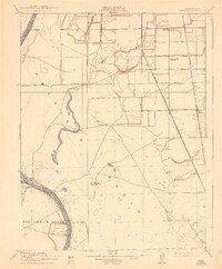
1910 Map of Vernon
USGS Topo · Published 1943About this map
Rio Jesus Maria and the Sacramento River dominate the southern landscape of this early 20th-century California survey. The confluence area is marked by the small settlement of Vernon and the Verona PO, which served as a vital junction for river traffic at Fremont Landing and Vernon Landing. The map illustrates a transitional period in transportation, where traditional river landings are surveyed alongside established rail lines like the Southern Pacific RR and the Northern Electric line cutting through the American Basin. Inland, the rural character is defined by family-named landmarks and schools such as Lee School and Cottonwood School. The survey captures the intricate drainage network of Burkham Slough, Coon Creek, and Curry Creek before large-scale modern reclamation fully altered the hydrology of the basin.
Find a feature on this map
25 named features on this map. Tap any name to fly to it.
Don’t see what you’re looking for? This feature index may not catch every label — zoom into the map to look around manually.
Map Details
Editions of this 1910 Vernon Map
2 editions found
Other maps of this area

1891 · Sacramento
USGS Topo · 1:125,000

1892 · Sacramento
USGS Topo · 1:125,000

1893 · Sacramento
USGS Topo · 1:125,000

1902 · Fairoaks
USGS Topo · 1:62,500

1907 · Davisville
USGS Topo · 1:62,500

1910 · Sheridan
USGS Topo · 1:31,680

1910 · Knights Landing
USGS Topo · 1:31,680

1910 · Vernon
USGS Topo · 1:31,680

1910 · Nicolaus
USGS Topo · 1:31,680

1910 · Pleasant Grove
USGS Topo · 1:31,680