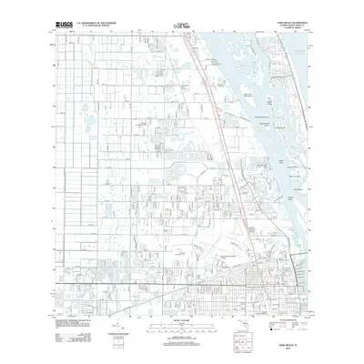
2012 Map of Vero Beach
USGS Topo · Published 2012About this map
Indian River and the Indian River Narrows dominate this coastal landscape, separating the mainland from a series of barrier islands and points including Johns Island, Gifford Island, and Bee Gum Point. On the mainland, the map reveals a highly structured grid of residential development and drainage infrastructure, most notably the Main Canal which cuts through the southern portion of the quadrangle. Aviation history is represented by the Vero Beach Municipal Airport and the smaller Brooke Air Patch Airport further north. Cultural and recreational landmarks are prominent throughout the area, from Hillcrest Memorial Gardens near the canal to several established courses like the Village Green Golf Course and Villa del Ray Golf Course. This survey captures the region as a developed coastal corridor, where managed waterways and golf courses define the modern layout of Copelands Landing and the surrounding communities.
Find a feature on this map
216 named features on this map. Tap any name to fly to it.
Don’t see what you’re looking for? This feature index may not catch every label — zoom into the map to look around manually.
Map Details
Editions of this 2012 Vero Beach Map
This is the sole edition of this map. No revisions or reprints were ever made.
Other maps of this area

1948 · Riomar
USGS Topo · 1:24,000

1948 · Indrio
USGS Topo · 1:24,000

1949 · Fellsmere
USGS Topo · 1:24,000

1949 · Vero Beach
USGS Topo · 1:24,000

1949 · Sebastian
USGS Topo · 1:24,000

1949 · Oslo
USGS Topo · 1:24,000

1950 · Riomar
USGS Topo · 1:24,000

1950 · Oslo
USGS Topo · 1:24,000

1950 · Indrio
USGS Topo · 1:24,000

1950 · Vero Beach
USGS Topo · 1:24,000