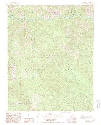
1987 Map of Verplank Ridge
USGS Topo · Published 1987About this map
The Kings River carves a deep valley through the high country of the Sierra National Forest and Sequoia National Forest in this late 1980s topographical record. The landscape is defined by massive topographic features including Pine Ridge, McKenzie Ridge, and Verplank Ridge, with Mt Sampson standing as a primary high point. Human presence is sparse and largely historical, marked by sites such as Rancheria (Site) and Goodmill (Site). The transition from the river valley to the ridgelines is steep, only accessible by primitive 4wd routes and seasonal camps. This survey provides a precise look at the forest infrastructure of the era, from the Delilah Lookout and Radio Facility to established riverfront recreation areas like Mill Flat Campground and Rodgers Crossing.
Find a feature on this map
41 named features on this map. Tap any name to fly to it.
Don’t see what you’re looking for? This feature index may not catch every label — zoom into the map to look around manually.
Map Details
Editions of this 1987 Verplank Ridge Map
2 editions found
Other maps of this area

1903 · Tehipite
USGS Topo · 1:125,000

1905 · Tehipite
USGS Topo · 1:125,000

1922 · Trimmer
USGS Topo · 1:96,000

1924 · Dinuba
USGS Topo · 1:125,000

1942 · Dunlap
USGS Topo · 1:62,500

1944 · Dunlap
USGS Topo · 1:62,500

1948 · Fresno
USGS Topo · 1:250,000

1952 · Tehipite Dome
USGS Topo · 1:62,500

1952 · Patterson Mountain
USGS Topo · 1:62,500

1955 · Fresno
USGS Topo · 1:250,000