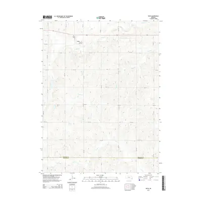
2014 Map of Vesta
USGS Topo · Published 2014About this map
The small unincorporated community of Vesta sits at a crossroads in Johnson County, defined by a rolling landscape carved by numerous small watercourses. This survey illustrates a rural Nebraska township dominated by agriculture, where the town's history is anchored by the Vesta Cem located just north of the residential cluster. The drainage pattern is particularly dense here, with Yankee Cr flowing across the northern section and Turkey Cr crossing the southern boundary between Johnson Co and Pawnee Co. The intricate network of local roads, such as 726th Rd and 720 Rd, follows the section lines of the Public Land Survey System, providing access to the various branches of the creek system, including Brewers Br, Sampson Br, and Badger Br.
Find a feature on this map
21 named features on this map. Tap any name to fly to it.
Don’t see what you’re looking for? This feature index may not catch every label — zoom into the map to look around manually.
Map Details
Editions of this 2014 Vesta Map
This is the sole edition of this map. No revisions or reprints were ever made.
Other maps of this area

1955 · Lincoln
USGS Topo · 1:250,000

1957 · Lincoln
USGS Topo · 1:250,000

1958 · Lincoln
USGS Topo · 1:250,000

1965 · Crab Orchard
USGS Topo · 1:24,000

1965 · Burchard
USGS Topo · 1:24,000

1965 · Sterling
USGS Topo · 1:24,000

1965 · Tecumseh
USGS Topo · 1:24,000
1965 · Steinauer
USGS Topo · 1:24,000

1965 · Lewiston
USGS Topo · 1:24,000
1965 · Tecumseh NW
USGS Topo · 1:24,000