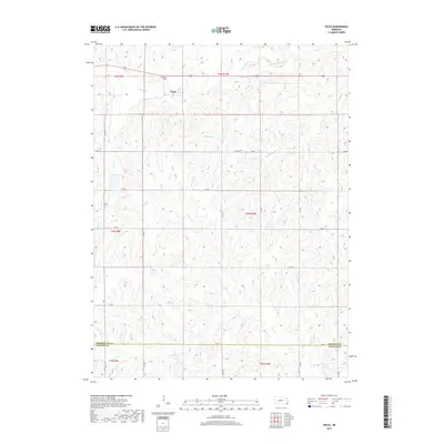
2017 Map of Vesta
USGS Topo · Published 2017About this map
The settlement of Vesta sits at the northern end of this agricultural landscape in Johnson County, serving as the primary hub for the surrounding rural area. Located just northwest of the town center, the Vesta Cem provides a focal point for genealogical research and local history. The topography is defined by a dense network of watercourses, including the prominent Yankee Creek and Turkey Cr, which are joined by numerous smaller tributaries such as Brewers Br, Sampson Br, and Lost Br. These streams carve through the terrain, creating the drainage patterns that have historically shaped the placement of farmsteads and the rectangular road grid. Along the southern border, the line between Johnson Co and Pawnee Co is marked by 720 Rd, illustrating the transition between these two Nebraska counties.
Find a feature on this map
25 named features on this map. Tap any name to fly to it.
Don’t see what you’re looking for? This feature index may not catch every label — zoom into the map to look around manually.
Map Details
Editions of this 2017 Vesta Map
This is the sole edition of this map. No revisions or reprints were ever made.
Other maps of this area

1955 · Lincoln
USGS Topo · 1:250,000

1957 · Lincoln
USGS Topo · 1:250,000

1958 · Lincoln
USGS Topo · 1:250,000

1965 · Crab Orchard
USGS Topo · 1:24,000

1965 · Burchard
USGS Topo · 1:24,000

1965 · Sterling
USGS Topo · 1:24,000

1965 · Tecumseh
USGS Topo · 1:24,000
1965 · Steinauer
USGS Topo · 1:24,000

1965 · Lewiston
USGS Topo · 1:24,000
1965 · Tecumseh NW
USGS Topo · 1:24,000