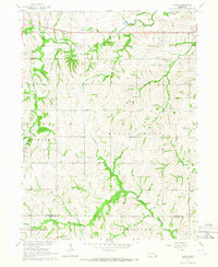
1965 Map of Vesta
USGS Topo · Published 1966About this map
Vesta serves as the primary settlement in this corner of Johnson County, situated along the valley of Yankee Creek. The landscape is defined by the transition from upland townships like Maple Grove and Western to the drainage basins of Turkey Creek and Todd Creek. One of the most distinctive markers of the area's changing infrastructure is the Old Railroad Grade running west to east, tracing a bypassed path of regional transport. Rural life in the mid-1960s is evidenced by the distribution of several schoolhouses, including Stony Point Sch and School No 8, alongside community landmarks like St Pauls Ch and the Vesta Cem. The map also captures the boundary where Johnson and Pawnee counties meet, showing the agricultural parceling of the high plains.
Find a feature on this map
23 named features on this map. Tap any name to fly to it.
Don’t see what you’re looking for? This feature index may not catch every label — zoom into the map to look around manually.
Map Details
Editions of this 1965 Vesta Map
This is the sole edition of this map. No revisions or reprints were ever made.
Other maps of this area

1955 · Lincoln
USGS Topo · 1:250,000

1957 · Lincoln
USGS Topo · 1:250,000

1958 · Lincoln
USGS Topo · 1:250,000

1965 · Crab Orchard
USGS Topo · 1:24,000

1965 · Burchard
USGS Topo · 1:24,000

1965 · Sterling
USGS Topo · 1:24,000

1965 · Tecumseh
USGS Topo · 1:24,000
1965 · Steinauer
USGS Topo · 1:24,000

1965 · Lewiston
USGS Topo · 1:24,000
1965 · Tecumseh NW
USGS Topo · 1:24,000