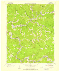
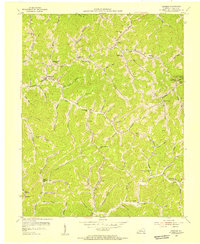
1954 Map of Vicco
USGS Topo · Published 1956About this map
Carr Fork and the Louisville and Nashville railroad define the industrial and residential corridors of this Perry County landscape during the mid-1950s. The map illustrates a dense network of coal-era settlements and hollows, where small mining-related communities like Wiscoal, Vicco, and Anco follow the narrow valleys. The presence of numerous institutions, such as the Open Door Childrens Home near Cornettsville and various rural schoolhouses like Georges Branch Sch and Big Branch Sch, suggests a series of established, self-sufficient valley communities separated by the steep ridges of the Cumberland Plateau.
Find a feature on this map
86 named features on this map. Tap any name to fly to it.
Don’t see what you’re looking for? This feature index may not catch every label — zoom into the map to look around manually.
Map Details
Editions of this 1954 Vicco Map
4 editions found
Other maps of this area

1890 · Whitesburg
USGS Topo · 1:125,000

1891 · Hazard
USGS Topo · 1:125,000

1892 · Whitesburg
USGS Topo · 1:125,000

1912 · Hindman
USGS Topo · 1:48,000

1913 · Oven Fork
USGS Topo · 1:48,000

1914 · Troublesome
USGS Topo · 1:62,500

1915 · Hindman
USGS Topo · 1:62,500

1915 · Whitesburg
USGS Topo · 1:62,500

1916 · Cornettsville
USGS Topo · 1:62,500
1954 · Hindman
USGS Topo · 1:24,000