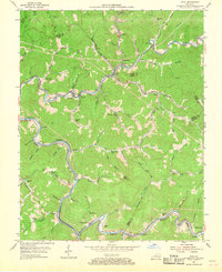
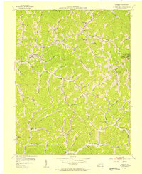
1954 Map of Vicco
USGS Topo · Published 1968About this map
Louisville and Nashville rail lines follow the winding river valleys of this Eastern Kentucky landscape, serving a series of tight-knit coal and rail communities in the mid-1950s. The settlement of Vicco sits at a critical junction where Carr Fork meets local tributaries, surrounded by neighboring towns like Sassafras, Anco, and Happy. The geography is defined by a dense network of named hollows and branches, such as Red Oak Branch and Lick Fork, where local life centered around small institutions like Indian Bottom Ch and numerous rural schoolhouses including Georges Branch Sch and Fort Branch Sch. Industrial activity is evident through numerous Conveyor lines and a Substation near Kodak, while the ridge at Dixon Knob is marked by a Lookout Tower. This survey captures the region just before significant modernization, documenting the exact placement of the Open Door Childrens Home and the many family cemeteries that dot the hillsides.
Find a feature on this map
87 named features on this map. Tap any name to fly to it.
Don’t see what you’re looking for? This feature index may not catch every label — zoom into the map to look around manually.
Map Details
Editions of this 1954 Vicco Map
4 editions found
Other maps of this area

1890 · Whitesburg
USGS Topo · 1:125,000

1891 · Hazard
USGS Topo · 1:125,000

1892 · Whitesburg
USGS Topo · 1:125,000

1912 · Hindman
USGS Topo · 1:48,000

1913 · Oven Fork
USGS Topo · 1:48,000

1914 · Troublesome
USGS Topo · 1:62,500

1915 · Hindman
USGS Topo · 1:62,500

1915 · Whitesburg
USGS Topo · 1:62,500

1916 · Cornettsville
USGS Topo · 1:62,500
1954 · Hindman
USGS Topo · 1:24,000