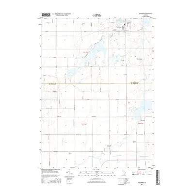
2014 Map of Vicksburg
USGS Topo · Published 2014About this map
Vicksburg serves as the primary hub in this southwestern Michigan landscape, where a dense network of glacial lakes and waterways dictates the local geography. The village is flanked by Sunset Lake to the north and a chain of water bodies including Barton Lake, Kimble Lake, and Portage Lake to the south. This area, spanning the border between Kalamazoo and St. Joseph counties, is defined by its agricultural character and historical burial grounds, such as Schoolcraft Township Cem and Mint Cem. To the south, the small settlement of Parkville sits near the winding course of the Portage River. The presence of the Thrall Lake Airport and a grid of rural routes like Michigan Ave and Marcellus Rd illustrates the modern connectivity of this region, while the various drains, such as Garman Foster Drain, reflect long-standing efforts to manage the low-lying terrain for cultivation.
Find a feature on this map
60 named features on this map. Tap any name to fly to it.
Don’t see what you’re looking for? This feature index may not catch every label — zoom into the map to look around manually.
Map Details
Editions of this 2014 Vicksburg Map
This is the sole edition of this map. No revisions or reprints were ever made.
Other maps of this area

1914 · Three Rivers
USGS Topo · 1:62,500

1916 · Three Rivers
USGS Topo · 1:62,500

1918 · Leonidas
USGS Topo · 1:62,500

1922 · Schoolcraft
USGS Topo · 1:62,500

1943 · Three Rivers
USGS Topo · 1:62,500

1943 · Schoolcraft
USGS Topo · 1:62,500

1944 · Leonidas
USGS Topo · 1:62,500

1947 · Leonidas
USGS Topo · 1:62,500

1950 · Leonidas
USGS Topo · 1:62,500

1953 · Fort Wayne
USGS Topo · 1:250,000