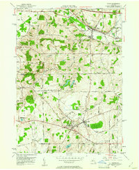
1951 Map of Victor
USGS Topo · Published 1961About this map
Lehigh Valley and New York Central rail lines converge in the town of Victor, marking a mid-century period when traditional transport networks met the dawn of the interstate era. This 1951 study documents the landscape just as the New York State Thruway began to reshape upstate New York's transit corridors. The terrain is defined by glacial features like Fort Hill and Boughton Hill, where numerous small water bodies including Cranberry Pond and Shackleton Pond feed the surrounding creek systems. Local history is deeply etched into the township through several family and community burial grounds, such as Tomlinson Corner Cem and Dibble Cem. To the south, the village of East Bloomfield and the adjacent settlement of Holcomb serve as key hubs in a region defined by agricultural plots and winding rural routes like Olmstead Road and Degman Road.
Find a feature on this map
38 named features on this map. Tap any name to fly to it.
Don’t see what you’re looking for? This feature index may not catch every label — zoom into the map to look around manually.
Map Details
Editions of this 1951 Victor Map
3 editions found
Other maps of this area

1895 · Rochester
USGS Topo · 1:62,500

1898 · Rochester
USGS Topo · 1:62,500

1900 · Macedon
USGS Topo · 1:62,500

1900 · Canandaigua
USGS Topo · 1:62,500

1901 · Honeoye
USGS Topo · 1:62,500

1903 · Canandaigua
USGS Topo · 1:62,500

1904 · Honeoye
USGS Topo · 1:62,500

1912 · Rochester
USGS Topo · 1:62,500

1920 · Rochester
USGS Topo · 1:62,500

1931 · Mendon Ponds
USGS Topo · 1:24,000