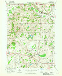
1951 Map of Victor
USGS Topo · Published 1968About this map
Victor stands as a central hub in the early 1950s, where the New York Central and Lehigh Valley railroads intersect, shaping the industrial and transport character of northwestern Ontario County. The landscape is defined by significant elevations such as Fort Hill and Boughton Hill, overlooking a network of agricultural lands and local settlements including East Bloomfield, Holcomb, and Ionia. This survey captures the transition of the region's infrastructure, notably featuring the New York State Thruway cutting across the northern reaches near Canandaigua Outlet. Genealogists and local historians will find a wealth of specific landmarks, from St Patricks Church to numerous family and community burial grounds like Tomlinson Corner Cem and French Cem. The water system is well-delineated, showing the Fairport Reservoirs, Mud Creek, and several ponds such as Sterling Pond and Shackleton Pond that dot the countryside.
Find a feature on this map
76 named features on this map. Tap any name to fly to it.
Don’t see what you’re looking for? This feature index may not catch every label — zoom into the map to look around manually.
Map Details
Editions of this 1951 Victor Map
3 editions found
Other maps of this area

1895 · Rochester
USGS Topo · 1:62,500

1898 · Rochester
USGS Topo · 1:62,500

1900 · Macedon
USGS Topo · 1:62,500

1900 · Canandaigua
USGS Topo · 1:62,500

1901 · Honeoye
USGS Topo · 1:62,500

1903 · Canandaigua
USGS Topo · 1:62,500

1904 · Honeoye
USGS Topo · 1:62,500

1912 · Rochester
USGS Topo · 1:62,500

1920 · Rochester
USGS Topo · 1:62,500

1931 · Mendon Ponds
USGS Topo · 1:24,000