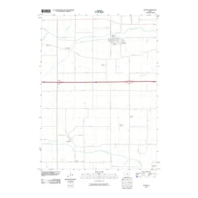
2010 Map of Victor
USGS Topo · Published 2010About this map
Victor and the surrounding agricultural lands of Iowa County are defined by a network of drainage ways and precisely plotted rural roads in this 2010 study. The town itself serves as a focal point, anchored by the Victor Post Office and bordered by the Calvary Cemetery and International Order of Odd Fellows Cemetery. To the southwest, the settlement of Guernsey sits near the North English River, illustrating the distribution of small communities across the plains. This landscape is rich with small family and community burial grounds, such as Wilson Cemetery, Gwin Cemetery, and Longstreth Cemetery, which offer valuable locations for genealogical research. The drainage patterns of Big Bear Creek in the north and Jordan Creek in the south show the natural hydrology that dictated early farm placement, while the Rinehart Airport indicates the modern utility of these open interior spaces.
Find a feature on this map
53 named features on this map. Tap any name to fly to it.
Don’t see what you’re looking for? This feature index may not catch every label — zoom into the map to look around manually.
Map Details
Editions of this 2010 Victor Map
This is the sole edition of this map. No revisions or reprints were ever made.
Other maps of this area

1954 · Des Moines
USGS Topo · 1:250,000

1956 · Des Moines
USGS Topo · 1:250,000

1957 · Des Moines
USGS Topo · 1:250,000

1965 · Ladora
USGS Topo · 1:24,000

1968 · Deep River
USGS Topo · 1:24,000

1968 · Brooklyn
USGS Topo · 1:24,000

1968 · Belle Plaine SW
USGS Topo · 1:24,000

1968 · Victor
USGS Topo · 1:24,000
1968 · Williamsburg NW
USGS Topo · 1:24,000

1968 · Hartwick
USGS Topo · 1:24,000