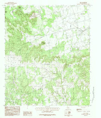
1984 Map of View
USGS Topo · Published 1984About this map
The Callahan Divide dominates the landscape of this Taylor County region, forming a prominent escarpment that separates the drainage systems of central Texas. The settlement of View sits at the intersection of local transportation routes on the flatter plains to the northeast, supported by a landscape of scattered Gravel Pits and a small Quarry that indicate the area's geological utility. The terrain is defined by a series of named summits and deep drainages, including Castle Peak and the curiously named Cat Heads. A network of ephemeral waterways like Little Elm Creek and Coon Hollow carve through the limestone heights. For the local historian, the presence of a rural Cem near the northern boundary and the transition from rugged peaks like Round Top Mountain to the rolling ranch land below provides a clear picture of the region's physical geography in the mid-1980s.
Find a feature on this map
21 named features on this map. Tap any name to fly to it.
Don’t see what you’re looking for? This feature index may not catch every label — zoom into the map to look around manually.
Map Details
Editions of this 1984 View Map
2 editions found
Other maps of this area

1890 · Abilene
USGS Topo · 1:125,000

1892 · Abilene
USGS Topo · 1:125,000

1893 · Sweetwater
USGS Topo · 1:125,000

1954 · Big Spring
USGS Topo · 1:250,000

1954 · Abilene
USGS Topo · 1:250,000

1957 · Merkel
USGS Topo · 1:62,500

1957 · Abilene West
USGS Topo · 1:24,000

1957 · Buffalo Gap
USGS Topo · 1:62,500

1958 · Big Spring
USGS Topo · 1:250,000

1958 · Abilene
USGS Topo · 1:250,000