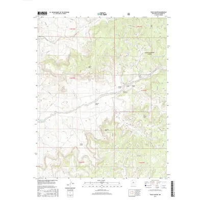
2017 Map of Vigas Canyon
USGS Topo · Published 2017About this map
Carson National Forest defines the eastern half of this high-desert landscape in Rio Arriba County, where a complex network of canyons and mesas shapes the drainage patterns of the Colorado Plateau. The terrain is characterized by broad elevated flats such as Vigas Mesa and Jaramillo Mesa, which are deeply incised by Vigas Canyon and Jaramillo Canyon. Water management is central to the land's utility, evidenced by a high density of named water features including Owl Tank, Temple Tank, and the notable Candelaria Waterhole. These features, along with numerous springs like Tecolote Spring and Vigas Spring, indicate the vital water sources required for livestock and land management in this arid region. The presence of Co Rd 518 and Co Rd 366 provides the primary access through the rugged geography, connecting the high ridges like Tuckers Ridge to the low drainage of Carrizo Creek.
Find a feature on this map
41 named features on this map. Tap any name to fly to it.
Don’t see what you’re looking for? This feature index may not catch every label — zoom into the map to look around manually.
Map Details
Editions of this 2017 Vigas Canyon Map
This is the sole edition of this map. No revisions or reprints were ever made.
Other maps of this area

1889 · Largo
USGS Topo · 1:250,000

1895 · Largo
USGS Topo · 1:250,000

1954 · Aztec
USGS Topo · 1:250,000

1958 · Aztec
USGS Topo · 1:250,000

1962 · Aztec
USGS Topo · 1:250,000

1963 · Lapis Point
USGS Topo · 1:24,000

1963 · Schmitz Ranch
USGS Topo · 1:24,000

1963 · Fourmile Canyon
USGS Topo · 1:24,000

1963 · Gobernador
USGS Topo · 1:24,000

1963 · Gonzales Mesa
USGS Topo · 1:24,000