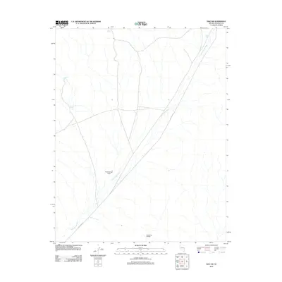
2012 Map of Vigo NW
USGS Topo · Published 2012About this map
Kane Springs Valley serves as the dominant geographic feature of this Lincoln County landscape, defining the broad corridor through which the arterial Kane Springs Rd travels. The map documents a desert environment where water sources are the primary landmarks for navigation and survival. Strategically located springs such as Kane Springs, Stewart Spring, and Sunflower Spring are noted along the periphery of the valley floor, highlighting the importance of these rare hydrological points in an arid region. The drainage patterns are clearly marked by the Kane Springs Wash, which cuts a distinct path through the valley, eventually meeting with the rugged opening of Hackberry Canyon. The settlement pattern is minimal, with the map focusing on the natural topography and the essential access routes that connect these remote desert basins.
Find a feature on this map
9 named features on this map. Tap any name to fly to it.
Don’t see what you’re looking for? This feature index may not catch every label — zoom into the map to look around manually.
Map Details
Editions of this 2012 Vigo NW Map
This is the sole edition of this map. No revisions or reprints were ever made.
Other maps of this area

1885 · Pioche
USGS Topo · 1:250,000

1886 · Pioche
USGS Topo · 1:250,000

1954 · Caliente
USGS Topo · 1:250,000

1959 · Caliente
USGS Topo · 1:250,000

1969 · Vigo NW
USGS Topo · 1:24,000
1969 · Delamar 3 SE
USGS Topo · 1:24,000

1969 · Gregerson Basin
USGS Topo · 1:24,000

1969 · Delamar 3 NE
USGS Topo · 1:24,000

1969 · Elgin
USGS Topo · 1:24,000
1969 · Vigo
USGS Topo · 1:24,000