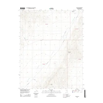
2015 Map of Vigo NW
USGS Topo · Published 2015About this map
Kane Springs Valley and the Meadow Valley Mountains define this high desert landscape in Lincoln County. The 2015 survey reveals a terrain shaped by vital water sources, including Kane Springs, Stewart Spring, and Sunflower Spring, which served as critical landmarks in an arid environment. The map details a network of primitive roads and trails, such as Kane Springs Rd and Kane Corral Rd, reflecting the region's ranching and transit history. The drainage pattern of Kane Springs Wash and the enclosure of Hackberry Canyon highlight the topographical character of the basin-and-range province. This record provides a clear look at the undeveloped expanses of southeastern Nevada, documenting the remote springs and canyons as they were managed at the start of the 21st century.
Find a feature on this map
15 named features on this map. Tap any name to fly to it.
Don’t see what you’re looking for? This feature index may not catch every label — zoom into the map to look around manually.
Map Details
Editions of this 2015 Vigo NW Map
This is the sole edition of this map. No revisions or reprints were ever made.
Other maps of this area

1885 · Pioche
USGS Topo · 1:250,000

1886 · Pioche
USGS Topo · 1:250,000

1954 · Caliente
USGS Topo · 1:250,000

1959 · Caliente
USGS Topo · 1:250,000

1969 · Vigo NW
USGS Topo · 1:24,000
1969 · Delamar 3 SE
USGS Topo · 1:24,000

1969 · Gregerson Basin
USGS Topo · 1:24,000

1969 · Delamar 3 NE
USGS Topo · 1:24,000

1969 · Elgin
USGS Topo · 1:24,000
1969 · Vigo
USGS Topo · 1:24,000