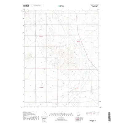
2018 Map of Vigus Butte
USGS Topo · Published 2018About this map
Vigus Butte rises as a central landmark in this high-desert basin of Central Nevada, overlooking the winding path of the Reese River. This drainage system, which flows through the eastern half of the map, represents a critical water source for the arid Great Basin landscape of Lander County. The riverbed is flanked by seasonal wetlands and tributary drainages such as Italian Cr, illustrating the hydrographic network that has sustained ranching and transit through this territory since early settlement. Sparse and undeveloped, the landscape is defined by the public land survey system, with townships t20n r42e and t19n r43e marking the gridded layout of the interior. The survey provides a clear view of the natural topography and the limited road infrastructure that crosses this isolated high-elevation terrain.
Find a feature on this map
7 named features on this map. Tap any name to fly to it.
Don’t see what you’re looking for? This feature index may not catch every label — zoom into the map to look around manually.
Map Details
Editions of this 2018 Vigus Butte Map
This is the sole edition of this map. No revisions or reprints were ever made.
Other maps of this area

1955 · Millett
USGS Topo · 1:250,000

1956 · Austin
USGS Topo · 1:62,500

1959 · Millett
USGS Topo · 1:250,000

1969 · Yankee Blade
USGS Topo · 1:24,000

1969 · Vigus Butte NE
USGS Topo · 1:24,000

1969 · Vigus Butte
USGS Topo · 1:24,000

1969 · Vigus Butte NW
USGS Topo · 1:24,000

1969 · Mount Airy NE
USGS Topo · 1:24,000

1969 · Gandolfo Canyon
USGS Topo · 1:24,000

1969 · Mount Airy Mesa
USGS Topo · 1:24,000